Introduction
Google Maps is one of the most useful tools for traveling in Japan.
You can use it to find train routes, station exits, walking directions, restaurants, convenience stores, hotels, attractions, bus stops, and travel times. For first-time visitors, it can make Japan feel much easier to navigate.
However, Google Maps is not perfect. Japanese stations can be huge, train platforms can be confusing, and some walking routes may send you through large underground areas or exits that are hard to find. If you know how to read the app properly, it becomes much more powerful.
This guide explains how to use Google Maps in Japan in a practical way, especially for trains, station exits, walking routes, and travel planning.
Quick Answer
Google Maps is very useful in Japan for:
- Train routes
- Walking directions
- Station exits
- Restaurant searches
- Convenience stores
- Hotel locations
- Bus routes
- Travel time estimates
- Saving places before your trip
For most travelers, it is enough for daily navigation.
But you should still check real station signs, platform information, and train direction before boarding.
Use Google Maps as your guide, then confirm with signs in the station.
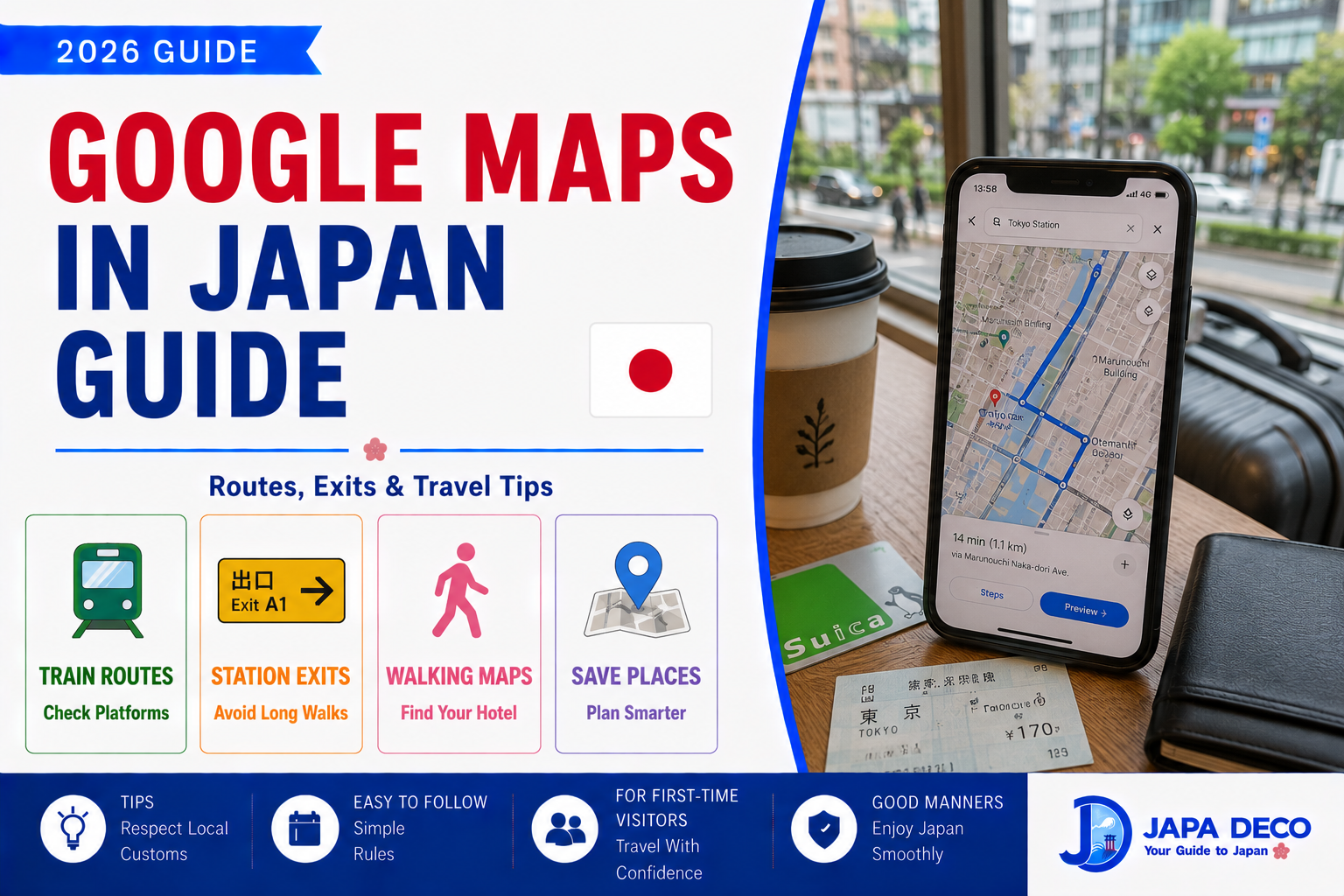
Using Google Maps for Trains
Google Maps works well for train travel in Japan.
When you search a route, it may show:
- Train line
- Departure time
- Arrival time
- Transfer station
- Platform number
- Train type
- Fare estimate
- Walking time
- Best route options
This is especially useful in cities like Tokyo, Osaka, Kyoto, and Fukuoka.
Before boarding, check:
- Train direction
- Platform number
- Local, rapid, or express
- Transfer station
- Final destination
Do not board only because the line color looks correct. Some trains share platforms, and rapid or express trains may skip certain stations.
【Image①】
Check Train Type Carefully
One common mistake is ignoring train type.
In Japan, trains may be:
- Local
- Rapid
- Express
- Limited Express
- Special Rapid
A local train usually stops at every station.
Rapid and express trains may skip stations.
If Google Maps says “Local,” do not automatically board a rapid train unless you confirm it stops at your destination.
This is especially important outside central Tokyo, or when traveling between cities like Osaka, Kyoto, and Nara.
If you are unsure, wait for the train shown in the app or check the station display.
Station Exits Are Very Important
Station exits matter a lot in Japan.
Large stations can have many exits, and the wrong exit can add 10 to 20 minutes of walking.
Google Maps often shows useful exit information, such as:
- East Exit
- West Exit
- South Exit
- Exit A1
- Exit B3
- Central Exit
Before leaving the station, check the suggested exit.
This is very important at stations such as:
- Shinjuku
- Tokyo
- Shibuya
- Ikebukuro
- Ueno
- Osaka
- Umeda
- Kyoto
- Namba
If Google Maps says to use Exit A2, look for signs inside the station before going outside.
Walking Directions
Google Maps is helpful for walking in Japan, but you should still pay attention.
In big cities, walking routes may include:
- Underground passages
- Pedestrian bridges
- Shopping arcades
- Station buildings
- Narrow side streets
- Multiple levels
Sometimes the app may show a route that looks simple, but the real path is confusing because you are underground or inside a station complex.
If the route feels wrong, zoom in and check nearby landmarks.
Convenience stores, station exits, hotel names, and major intersections are useful reference points.
Saving Places Before Your Trip
One of the best ways to use Google Maps is saving places before you travel.
Save:
- Hotels
- Airports
- Major stations
- Restaurants
- Cafes
- Attractions
- Convenience stores near your hotel
- Coin lockers
- Emergency locations
- Bus stops
- Shopping areas
This helps you move faster during the trip.
When you are tired, hungry, or standing in a crowded station, saved places make decisions easier.
You can also create lists such as:
- Tokyo food
- Kyoto temples
- Osaka restaurants
- Emergency
- Hotel area
Good preparation saves time later.
【Image②】
Restaurant Searches
Google Maps is useful for finding restaurants, but use it carefully.
You can check:
- Opening hours
- Reviews
- Photos
- Menu photos
- Price range
- Distance
- Busy times
- Reservation information
However, do not rely only on ratings.
Some excellent local restaurants may have few English reviews. Some tourist-heavy restaurants may have many reviews but long lines.
Look at recent photos and menu information.
If you have dietary restrictions, search more specifically, such as:
- vegetarian restaurant
- vegan ramen
- halal food
- gluten free
- English menu
For popular restaurants, check whether reservations are needed.
Convenience Stores and ATMs
Google Maps is very useful for finding convenience stores.
Search for:
- 7-Eleven
- FamilyMart
- Lawson
- convenience store
- ATM
This helps when you need:
- Cash
- Drinks
- Snacks
- Breakfast
- Umbrella
- Toilet
- Basic supplies
- Late-night food
Convenience stores are everywhere in cities, but in rural areas or late at night, checking the map is still helpful.
If you need an international ATM, 7-Eleven is often a practical place to search.
Buses on Google Maps
Google Maps can show bus routes in Japan, but buses are sometimes more confusing than trains.
Bus stops may be on different sides of the road, and the stop name may not be obvious.
When using buses, check:
- Bus stop location
- Bus direction
- Bus number
- Departure time
- Destination sign
- Payment method
- Where to get off
In Kyoto, buses are very useful but can be crowded.
For first-time visitors, trains and subways are usually easier than buses when available.
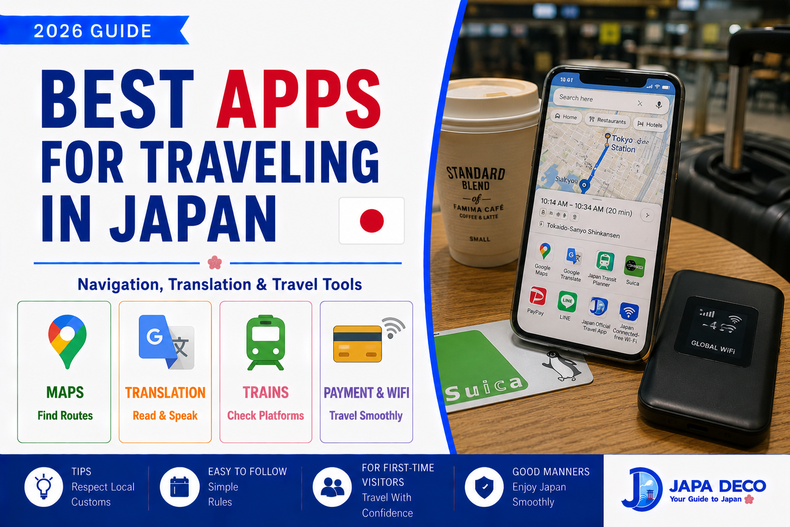
Offline and Battery Tips
Google Maps works best with internet access.
Before your trip, prepare:
- eSIM or pocket WiFi
- Power bank
- Hotel address screenshot
- Important route screenshots
- Offline map area if needed
Your phone battery can drain quickly because you will use maps, camera, translation, and train routes all day.
A power bank is one of the most useful travel items in Japan.
If your phone dies in a huge station, navigation becomes much harder.
【Image③】
Common Mistakes to Avoid
The first mistake is following Google Maps without checking signs.
Always confirm the platform, direction, and train type.
Another mistake is ignoring station exits. The wrong exit can create a long walk.
Some travelers also search only in English. For certain local places, Japanese names may produce better results.
Another mistake is not checking opening hours. Restaurants, shops, and attractions may close earlier than expected or have irregular holidays.
Finally, do not assume walking time is always comfortable with luggage. A 12-minute walk can feel much longer with a suitcase, rain, or stairs.
Best Way to Use Google Maps in Japan
The best approach is simple:
Use Google Maps for planning, but use real signs for confirmation.
Before moving, check:
- Destination
- Route
- Train line
- Platform
- Train type
- Station exit
- Walking route
During the trip, compare the app with station signs.
If they match, continue.
If they do not match, stop and check again.
This small habit prevents most navigation mistakes.
Conclusion
Google Maps is one of the most important apps for traveling in Japan.
It helps with train routes, station exits, walking directions, restaurants, convenience stores, hotels, attractions, and travel planning.
For first-time visitors, the biggest tips are simple: check train type, confirm platform direction, use the correct station exit, and save important places before your trip.
Google Maps is very useful, but it should not replace your own attention. Japanese stations are well signed, so use the app together with real signs.
If you prepare saved places, keep your phone charged, and follow routes carefully, Google Maps can make your Japan trip much smoother and less stressful.
Related Articles
Best Apps for Traveling in Japan
コメント